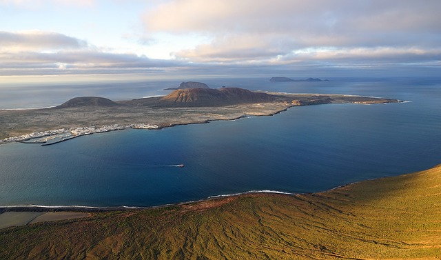
La Graciosa
Geography
Urban centers
The island of La Graciosa is located northwest of Lanzarote, from which it is separated by a strip of sea called El Río, together with the tiny islands of Montaña Clara, Roque del Este, Roque del Oeste and Alegranza, form the archipelago Chinijo. The surface extends for 29 km² and is currently the smallest inhabited island of the entire Canary archipelago with about 700 inhabitants. The urban centers present are La Caleta del Sebo, equipped with the main tourist services and Casas de Pedro Barba, which
constitutes a private tourist residential area.

Tourism
Excursions
Tourists interested in making an excursion to the island can leave from Arrecife and then arrive in Órzola, the fishing village, from where you can take the Órzola-La Graciosa line boat. The crossing takes about half an hour to reach the island of La Graciosa. In the urbanization of Caleta de Sebo the inhabitants practice fishing almost exclusively, therefore they offer tourists the possibility to taste the tasty fresh fish in the restaurants of the village. The island of La Graciosa has an infinity of beaches suitable for all types of water sports,
especially the Playa de Las Conchas.
,
Transportation
To get to La Graciosa, the only access route to the island is the sea, by means of a mainly tourist service of small boats that connect the port of Orzola, located in the north-west of the island of Lanzarote, with the small port of La Caleta del Sebo mainly equipped for fishing. In general, the island of Lanzarote is a tourist destination known throughout the world. Main attractions are the climate, the beautiful volcanic landscapes of Timanfaya and the long coastlines of golden beaches attract hundreds of thousands of visitors every year. The small territory hides a large number of surprises such as valleys and ravines exploited for cultivation, churches as evidence of the faith of the inhabitants, paths that lead to remote corners, all to be discovered. The island of Lanzarote is crossed by numerous paths and lanes developed according to the needs of the inhabitants who live on the island and represent the historical uses of the territory such as the search for water, salt, pastures for livestock. However, there is a series of paths and alternative routes in the area designed for tourists to bring the visitor closer to the natural and historical values of this wonderful island. La Graciosa is the first island on which the famous Norman explorer Juan de Bethencourt landed, under the reign of Henry III of Castile during the month of June 1402.
Territory
Like the entire Canarian archipelago, the island of La Graciosa is of volcanic origin. The main activities are fishing, and of course tourism. The territory is characterized by stupendous beaches beaten by the Atlantic, very beautiful are those of the coast facing North-West, such as the Playa de las Conchas, formed by red sand, mixed with shells dragged by the waves, with a wonderful view of the islet by Allegranza. Particularly interesting is also the Marine Reserve which extends over a rectangular area of 70,000 hectares of which about 60 percent is in internal territorial waters while the remaining 40 percent is found in external territorial waters. The Marine Reserve of La Graciosa was established on the initiative of the fishing sector and has the support of the Spanish Institute of Oceanography and the University of La Laguna. This area of the archipelago is influenced by the outcrop of cold waters, rich in fish from the African coast, of little depth, with the formation of very clear and luminous waters. The major reliefs are formed by volcanic cones whose maximum height is 266 m in the peak of Las Agujas. The interior of the island is mainly desert, small shrubs on the hard sand are the most frequent vegetation observable in the interior areas. The fauna includes small farm animals and wild rabbits. The characteristic climate of the Canary Islands yes distinguished above all by the scarcity of rains.